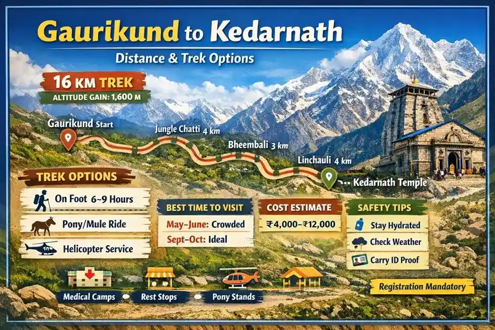
The Gaurikund to Kedarnath distance is approximately 16–18 kilometers, depending on the trekking route and small diversions taken during the journey. This stretch connects Gaurikund to the sacred temple town of Kedarnath Temple in the Rudraprayag district of Uttarakhand.
In real life, the trek feels longer than the number suggests. The altitude gain, unpredictable mountain weather, and crowd movement during peak yatra season make it physically demanding. Yet, for many pilgrims, this climb is not just a journey — it’s part of the spiritual test.
This guide covers verified distance details, route breakdown, trek options, cost comparison, safety advice, and ground-level insights that most travel blogs skip.
Gaurikund to Kedarnath Distance
After the 2013 disaster, the original trekking route was destroyed. The current route was reconstructed by the Uttarakhand government and the Border Roads Organisation.
Official distance today:
👉 16 km (approximate)
👉 Can stretch to 17–18 km depending on diversions and weather repairs
Altitude Details
| Location | Altitude |
|---|---|
| Gaurikund | ~1,982 meters |
| Kedarnath Temple | ~3,583 meters |
| Total Elevation Gain | ~1,601 meters |
That steep elevation gain is what makes this trek challenging.
What most people don’t realize is that oxygen levels drop significantly as you approach Kedarnath. Fatigue is common even among regular walkers.
Suggested to Read:
Route Map: Step-by-Step Trek Breakdown
The trek follows the Mandakini River valley. Here’s the ground-level route structure:
| Stretch | Approx Distance | Notes |
|---|---|---|
| Gaurikund → Jungle Chatti | 4 km | Moderate climb |
| Jungle Chatti → Bheembali | 3 km | Relief camps available |
| Bheembali → Linchauli | 4 km | Steeper section |
| Linchauli → Kedarnath Base | 4–5 km | High altitude zone |
The path is paved, wide, and monitored by SDRF and police teams during the yatra season.
On the ground, you’ll see:
-
Medical aid posts every few kilometers
-
Food stalls (seasonal)
-
Rest sheds
-
Mule and porter stands
Trek Options from Gaurikund to Kedarnath
Not everyone walks the full route. Thankfully, there are multiple options.
1. On Foot (Traditional Trek)
Distance: 16 km
Time: 6–9 hours (depending on pace)
Best for:
-
Physically fit pilgrims
-
Younger travelers
-
Spiritual seekers who want full experience
From practical experience, early morning start (4:30–5:30 AM) makes a huge difference. Weather is clearer. Crowd density is lower.
2. Pony / Mule Service
Available from Gaurikund.
| Service | One-Side Cost (Approx) |
|---|---|
| Pony | ₹2,500–₹3,500 |
| Porter (Pithu) | ₹3,000–₹4,000 |
| Palanquin (Doli) | ₹5,000–₹7,000 |
Rates are regulated by district authorities and revised annually.
Important:
-
Always book from authorized counters.
-
Avoid private negotiations during peak rush.
3. Helicopter Option (Partial Alternative)
Helicopters operate from nearby bases like:
-
Phata
-
Sersi
-
Guptkashi
Not directly from Gaurikund.
One-way fare: ₹2,500–₹5,500 (varies yearly)
Helicopter drops pilgrims near Kedarnath helipad, after which a short 500–700 meter walk remains.
During high demand, tickets sell out quickly via official IRCTC or state-approved portals.
Best Time to Do the Trek
The Kedarnath temple usually opens in April/May and closes around October/November, depending on Hindu calendar decisions announced by temple authorities.
Seasonal Breakdown
| Month | Condition | Recommendation |
|---|---|---|
| May–June | Heavy crowd | Start very early |
| July–August | Rain risk | Avoid if possible |
| September | Clear skies | Best time |
| October | Cold but peaceful | Good for experienced travelers |
According to reports from The Times of India and Hindustan Times, sudden weather changes and landslides are common during monsoon months.
On the ground, September offers the most stable weather and manageable crowd levels.
How to Reach Gaurikund
Gaurikund is the last motorable point before Kedarnath.
By Road
Connected from:
-
Haridwar
-
Rishikesh
-
Rudraprayag
-
Guptkashi
Nearest railway station: Rishikesh Railway Station
Nearest airport: Jolly Grant Airport
From these points, taxis and buses operate toward Sonprayag. From Sonprayag, shared jeeps take pilgrims to Gaurikund.
Common Mistakes Pilgrims Make
From real yatra observation:
-
Starting trek late (after 9 AM)
-
Ignoring altitude sickness symptoms
-
Wearing new shoes
-
Skipping rain protection
-
Not carrying ID proof
Also, many underestimate the Gaurikund to Kedarnath distance because 16 km on mountains feels very different from 16 km on flat land.
Safety Tips for the Trek
The Uttarakhand government has significantly improved safety after 2013, but personal responsibility still matters.
Practical Safety Checklist:
-
Carry medical certificate if above 50
-
Stay hydrated
-
Walk slowly after Linchauli
-
Avoid overtaking mules from valley side
-
Check official weather updates
Emergency helplines are active during yatra season, and medical camps operate throughout the route.
Cost Breakdown (Full Journey Estimate)
| Expense | Budget Range |
|---|---|
| Registration | Free (online mandatory) |
| Transport to Gaurikund | ₹800–₹2,000 |
| Trek (on foot) | Free |
| Pony | ₹3,000 approx |
| Helicopter | ₹5,000 approx |
| Accommodation | ₹800–₹3,000 per night |
Total estimated cost:
₹4,000–₹12,000 depending on travel style.
Physical Preparation Guide
If you’re planning this trek, start preparation at least 4 weeks before.
Simple routine:
-
4–5 km daily walking
-
Stair climbing practice
-
Light breathing exercises
What most people don’t realize is that knee pain is more common during descent than ascent.
Ground Reality: Crowd & Queue Time
During peak season:
-
Darshan wait time: 3–6 hours
-
Pony booking queue: 1–2 hours
Early arrival reduces waiting drastically.
Frequently Asked Questions
1. What is the exact Gaurikund to Kedarnath distance?
Approximately 16 km via the new trekking route.
2. How long does it take to complete the trek?
6–9 hours on average.
3. Is the trek difficult?
Moderate to difficult due to altitude gain.
4. Can senior citizens complete it?
Yes, with pony or palanquin support.
5. Is registration mandatory?
Yes, online or offline biometric registration is required.
6. Are food stalls available?
Yes, seasonal stalls operate along the route.
7. Is mobile network available?
Limited. BSNL works best in higher areas.
8. What happens during bad weather?
Authorities may temporarily stop trekking.
9. Is accommodation available at Kedarnath?
Yes, GMVN lodges, dharamshalas, and tents operate during season.
10. Is medical support available?
Yes, multiple medical relief camps are set up.
Final Practical Advice
The Gaurikund to Kedarnath distance may sound simple on paper. But in reality, it’s a high-altitude Himalayan climb with unpredictable conditions.
If you prepare physically, start early, choose the right option (walk, pony, helicopter), and respect the mountain environment, the journey becomes manageable.
For many pilgrims, reaching Kedarnath after completing the trek feels far more rewarding than any shortcut.
And that’s something no map can measure.
Suggested Tour: